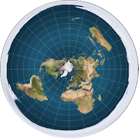
35. Lines of latitude do not converge the further south they are and captains travelling in the southern hemisphere go off course if they assume the Earth is a sphere
“If the Earth were truly a globe, then every line of latitude south of the equator would have to measure a gradually smaller and smaller circumference the farther South travelled. If, however, the Earth is an extended plane, then every line of latitude south of the equator should measure a gradually larger and larger circumference the farther South travelled. The fact that many captains navigating south of the equator assuming the globular theory have found themselves drastically out of reckoning, more so the farther South travelled, testifies to the fact that the Earth is not a ball.”
Dubay makes another outright lie.
This is an example of Dubay "getting in first" by denying easily proved facts which debunk flat Earth.
 The flat Earth map with its huge distances between southern most points on the Earth that can be easily proven false. E.g. South America to South Africa to Australia.
The following colour coded map shows container traffic over the course of a year. There are thousands of journey's taking place in the southern hemisphere. Are we really supposed to believe that all these ship's captains don't know where that are going and are part of the conspiracy to cover up the inaccurate maps that they are made to use? Really?
If you are going to make ridiculous claims at least provide some evidence. Any evidence will do but make it modern, not some 17th century captain please.
Here is an experiment that you can perform yourself from your computer using documented flight plans that you can look up on Expedia.com that shows that the flat earth distances do not work.:
< Prev 31-40 Next >
Dubay makes another outright lie.
This is an example of Dubay "getting in first" by denying easily proved facts which debunk flat Earth.
 The flat Earth map with its huge distances between southern most points on the Earth that can be easily proven false. E.g. South America to South Africa to Australia.
The following colour coded map shows container traffic over the course of a year. There are thousands of journey's taking place in the southern hemisphere. Are we really supposed to believe that all these ship's captains don't know where that are going and are part of the conspiracy to cover up the inaccurate maps that they are made to use? Really?
If you are going to make ridiculous claims at least provide some evidence. Any evidence will do but make it modern, not some 17th century captain please.
 |
| Source: https://www.wired.com/2010/01/global-shipping-map/ |
Here is an experiment that you can perform yourself from your computer using documented flight plans that you can look up on Expedia.com that shows that the flat earth distances do not work.:
- Pick the flat Earth map that you believe in.
- Look up the flight times for a direct flight from Johannesburg to Sydney. (E.g. Qantas flight QF63/QF6)
- Next look up the flight times for a British Airways flight from Johannesburg to New York. There are no direct flights but there are flights with one stop over in London which makes a near straight line on most flat Earth maps. (E.g. Flight BA57 + BA175)
- Remember to subtract the London stop-over time from the Johannesburg to New York flight time to get the true flight time.
- You will notice that the flight time for Johannesburg to Sydney is 11 hours 40 minutes, and the flight time for Johannesburg to New York is 19 hours and 30 minutes. 8 hours longer.
- Now look at your flat earth map. You will clearly see that the distance from Johannesburg to Sydney is longer than the distance from Johannesburg to New York. By measuring the pixels in the diagram below calculate 49% longer. How do you explain the longer distance taking a 8 hours / 40% less time?
- Now consider the speed of the aircraft. The distance flown from Johannesburg to New York via London is 9100 miles, which makes the average speed of the aircraft's 19.5 hour flight 467 miles per hour. This agrees with the known typical speeds for commercial aircraft. For an aircraft to fly 49% further in 40% less time the average speed would need to be approximately 1160 miles per hour. Since the fastest airliner the Airbus 380's top speed is only 676 miles per hour we can see that this would be impossible to achieve.
With a spherical Earth it makes sense. On a spherical Earth the distance from Johannesburg to Sydney is 6868 miles which is 25% shorter than the 9100 miles from Johannesburg to New York via London. To achieve the journey in the documented 11 hours 40 minutes, the aircraft would need to fly at 592 miles per hour, a speed within the capability of current airliners.
So in conclusion, this shows that the claims of Dubay are actually physically impossible and once again shows him to be a liar.
So in conclusion, this shows that the claims of Dubay are actually physically impossible and once again shows him to be a liar.
< Prev 31-40 Next >


Comments
Post a Comment